Local Watches / Warnings

Showing posts with label temperature. Show all posts

Friday, November 2, 2012

Drought Update: Current and Outlook for Georgia, Southeast, United States - November 2 2012

Drought in Georgia still persists and gained ground during the dry month of October. While drought has yet to relinquish it's hold on areas of North and Central Georgia, it's slowly creeping back into areas of south Georgia. During this time of year folks don't think much about drought conditions as the lush green vegetation is slowly turning brown and going dormant across the state as fall and winter moves in.

The difference a month makes since my last drought update October 6 2012


Drought still remains in Georgia and is gradually once again becoming worse due to lack of rain as area lakes and streams mainly in central Georgia continue to drop and some are at record lows during this time of year.

Rainfall in Georgia and the United States over the last 30 days


CLIMATE IMPACTS - Georgia

GENERALLY ZERO TO 25 PERCENT OF NORMAL RAINFALL PREVAILED OVER NORTH AND CENTRAL GEORGIA DURING THE PAST 14 DAYS.
LOCATION   TOTAL RAINFALL    NORMAL    DEPARTURE     PERCENT
            LAST 365 DAYS    VALUE     FROM NORMAL   OF NORMAL

ATLANTA        36.35         49.76      -13.41         73%
ATHENS         37.30         46.38       -9.08         80%
COLUMBUS       37.20         46.81       -9.61         79%
MACON          32.33         45.74      -13.41         71%
-------------------------------------------------------------------
RESERVOIRS/STREAM LEVELS - Georgia

CURRENT LAKE LEVELS AT THE USACE PROJECTS WERE MAINLY FROM 2 TO 13 FEET BELOW SEASONAL POOL LEVELS. ALL OF THE LAKE LEVELS ARE PROJECTED TO SLOWLY FALL DURING THE NEXT FOUR WEEKS.
LAKE       SEASONAL POOL  CURRENT LEVEL   DEPARTURE
                                           IN FEET

ALLATOONA       832          830.15         -1.85
CARTERS        1073         1071.03         -1.97
HARTWELL        658          645.90        -12.10
LANIER         1071         1061.55         -9.45
THURMOND        329          316.13        -12.87
WEST POINT      634          623.16        -10.84
AVERAGE STREAM LEVELS FOR THE PAST 7 DAYS RANGED FROM AS LOW AS 1 PERCENT ON MUCH OF THE FLINT...OCMULGEE AND OCONEE RIVERS IN CENTRAL GEORGIA...TO AS HIGH AS 65 PERCENT ON THE CHATTAHOOCHEE RIVER IN ATLANTA DUE TO RECENT RAINFALL OR LACK THEREOF.

PLEASE NOTE THAT CREEKS AND SMALLER RIVERS CAN CHANGE QUICKLY DUE TO RUNOFF FROM HEAVY RAIN IF IT OCCURS.


Here's the current drought conditions across the southeast US October 2 thru 30 2012.


Here's the current drought conditions across the United States October 2 thru 30 2012.


Here's the Seasonal Drought Outlook November 1 2012 thru January 31 2013


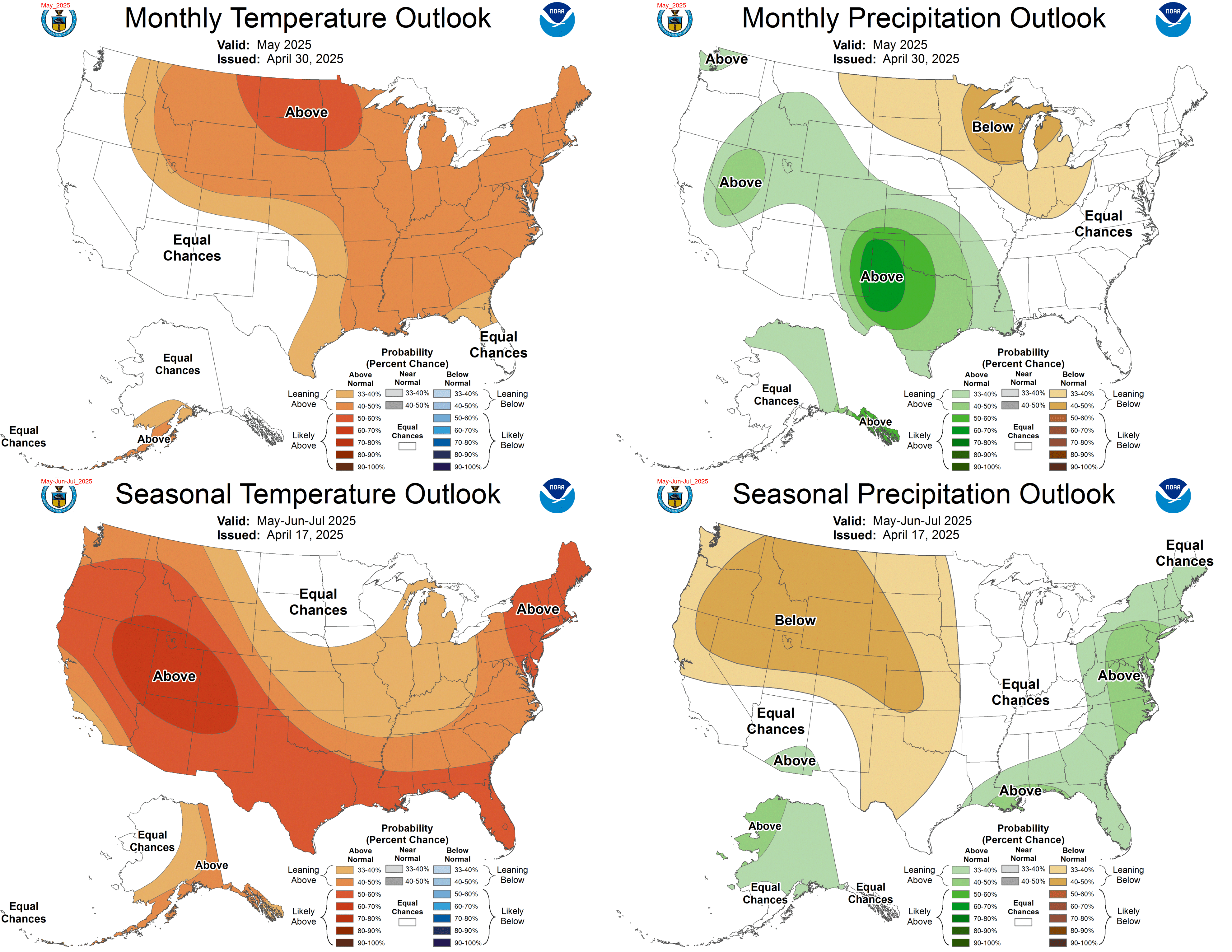
Here's the Outlook for November Rain and Temperatures as well as the three month outlook fro rain and temperature.


Sources:

http://droughtmonitor.unl.edu/monitor.html

http://water.weather.gov/precip/

http://www.cpc.ncep.noaa.gov/products/expert_assessment/seasonal_drought.html

http://www.cpc.ncep.noaa.gov/products/predictions/multi_season/13_seasonal_outlooks/color/page2.gif

http://forecast.weather.gov/product.php?site=NWS&issuedby=FFC&product=dgt&format=CI&version=1&glossary=1


Thursday, May 3, 2012

Georgia Drought Update - May 3 2012

As anticipated, the small area of drought improvement in Northeast Georgia last week, is all but gone this week.

Since my last drought update on April 23 2012, it has been quite dry across much of Georgia. Abnormally Dry conditions continue to cover much of North Georgia, with Moderate drought conditions beginning to creep back in.
Severe Drought conditions continue to hold in areas of Southeast and North central Georgia, ever so slowly creeping towards North Georgia.
Extreme Drought conditions now cover a large area of Georgia from North Central to the state line with Florida.
Exceptional Drought conditions, the highest level of drought, has expanded in Central Georgia while other areas experiencing Exceptional Drought in south Georgia remaining unchanged since my last report.

The overall breakdown on drought conditions in Georgia as of May 1 2012 are as follows:

The entire state of Georgia is experiencing Abnormally Dry conditions, 96.50 %, except for a small area mentioned in North GA.
Moderate Drought covers 88.56 % of the state.
Severe Drought covers 84.28 % of the state.
Extreme Drought covers 70.94 % of the state.
Exceptional Drought covers 25.85 % of the state.

Here's a graphic showing Drought conditions from April 17 thru May 1 2012


To show how dry it has been in Georgia and much of the southeast, here's a graphic showing how much rain these areas have seen since the beginning of 2012. Notice the areas of Red in Georgia and Florida; these areas have only received 50 to 25 percent of normal rainfall since the start of the year.


To put the above in perspective, here's a graphic showing departure from normal rainfall from May of 2011 thru April 2012. Much of Georgia is showing a deficit of 8 inches with areas in southwest Georgia pushing the 20 inch below normal mark.


Here's a look at precipitation or lack of for select areas around the state of Georgia through May 2 2012.

This first table shows total rainfall for the last 365 days:
LOCATION   TOTAL RAINFALL    NORMAL    DEPARTURE     PERCENT
            LAST 365 DAYS    VALUE     FROM NORMAL   OF NORMAL

ATLANTA         32.33        49.74       -17.41        65%
ATHENS          29.11        46.39       -17.28        63%
COLUMBUS        38.40        46.81        -8.41        82%
MACON           28.91        45.75       -16.84        63%

This table shows total rainfall fro the last 90 days:
LOCATION   TOTAL RAINFALL    NORMAL    DEPARTURE     PERCENT
           (LAST 90 DAYS)    VALUE     FROM NORMAL   OF NORMAL

ATLANTA         7.53         12.91        -5.38        58%
ATHENS          5.89         12.12        -6.23        49%
COLUMBUS        7.88         13.52        -5.64        58%
MACON           5.30         11.87        -6.57        45%

At this time it's looking like drought conditions will continue to expand and intensify for Georgia. I expect the same can be said for much of the southeast as I see no reason at this time not to think this. It appears a summer type pattern has set up early this year with scattered hit and miss showers and storms, and as earlier this week in Georgia, above average and record breaking high temperatures. Showers and storms of this type offer little relief for drought stricken areas, and what little rain may fall is quickly absorbed in the dry earth and back into the atmosphere.

Here's a look at Drought conditions across the rest of the U.S.:


And the latest Drought Outlook released May 3 2012:


For past Drought reports see the Drought Files. From 2007 to current date.


Monday, January 2, 2012

A couple things to check on your Car for Winter driving

Antifreeze

Make sure your antifreeze is still able to protect your radiator and engine from freezing. A few dollars now will save thousands later. To self check you will need a hydrometer [antifreeze/coolant tester] to check the concentration of ethylene glycol antifreeze in the coolant, or a refractometer if you use propylene glycol antifreeze/coolant. A refractometer works with either type of antifreeze. A 50/50 mixture of antifreeze and water for adequate freezing, boiling and corrosion protection is a must for long engine life. A 50/50 mixture of ethylene glycol antifreeze should protect down to a temperature of -34°F, and a 50/50 mix of propylene glycol antifreeze down to -26°F.

Tire pressure

You also need to check your 'tire pressure'. You should check your tire pressure once a month regardless of the season. During cooler / colder months of the year, air pressure will drop. This will cause excessive wear and heating of the tire due to more rubber being in contact with the road surface. This also leads to premature blow outs which may cause you to loose control when driving at higher speeds. The same is true during summer / warmer months of the year. During warmer months, air will expand causing the tire to become over-inflated. As you drive the pressure will build to more than the tire is rated and to handle. Proper tire inflation is a must for safe driving. It also saves you money buy using less gas, and your tires will last longer.

I hope these tips will help you and your car!

Thursday, August 18, 2011

Georgia Drought Update August 18 2011

In the last Drought update on August 11 I mentioned that I had some decent rains as well as other spots around the local area. In that post I also mentioned that the rains were not reflected in that weekly report. Well, It really had no effect on drought conditions in the local area. Why ? Because we have had little in the way of rain since that time, on August 8th. The last time it rained here at the homestead was August 11th. On that day I recorded 0.29 inches.

While we have enjoyed some cooler temperatures and lower humidity in the last week, we have seen no rain save a few short lived pop-up isolated showers. Some of those brought some good rain to the northern and eastern part of Harris county.
So not much has changed from last week to this in the local area. Other areas of the state have seen marked improvement. Here is the graph showing last week versus this week.


Here are Drought percentages covering the whole state.


And here is the rest of the Southeast.


Here is the Palmer Drought Severity Index showing how much rain is needed to bring conditions back to somewhat normal.


I wont bore you with the other graphs as they are not much different than last week either.


Saturday, July 2, 2011

Hot and Dry : Georgia June 2011 Climate Summary

If you happen to live in Georgia, you know it was Hot and Dry in June. If you've followed along here at Cataula GA WX you've read about some of the Record Breaking Heat, and Drought Conditions in Georgia. Here is the summary for June 2011......

Georgia Climate Summary for June 2011

Prepared by Pam Knox, Assistant State Climatologist
Georgia State Climatology Office

Very hot daytime temperatures and lack of rainfall led to strengthened drought across Georgia in June. Average temperatures were at or near record levels for the month across the state.

Temperatures across the state were above normal everywhere in Georgia for a fifth straight month. In Atlanta, the monthly average temperature was 81.2 degrees F (4.4 degrees above normal), in Athens 81.0 degrees (4.7 degrees above normal), Columbus 84.4 (5.2 degrees above normal), Macon 82.9 (4.9 above normal), Savannah 83.0 (4.2 above normal), Brunswick 82.4 (3.0 above normal), Alma 83.5 (4.2 above normal), Valdosta 83.3 (4.9 above normal) and Augusta 82.1 (4.6 above normal).

This was the warmest June ever in Columbus in 64 years of record. It was the second warmest in Macon in 119 years of record, only surpassed by 84.3 degrees F in June 1952. It was the third warmest June in 133 years of Atlanta records, surpassed by 82.3 degrees F in 1952 and 81.4 degrees F set last year in June 2010. Temperature records in Athens, Alma, Savannah, Valdosta and Augusta were also in the top ten Junes in their histories.

Numerous daily record high temperatures were broken this month. Columbus broke four daily records and tied three more, including 101 degrees F on June 1 and 3, breaking old records of 98 F and 99 F, set respectively in 1998 and 1985. Macon set their a daily record maximum temperature of 103 F on the third, breaking the old record of 102 F set in 1985. Alma set new daily temperature records on six different days, including a reading of 103 F on the 15th which broke the old record of 100 F set in 1981.

The NWS office in Savannah noted that their new daily maximum temperature record of 102 F on the 13th (breaking the old record of 100 F set in 1880) was the warmest it has been in Savannah since July 20, 2000.

Precipitation in June was scattered due to pup-up thunderstorms on many days during the month. The wettest areas were in northern Georgia and in the southeastern part of the state, where showers helped firefighters control the large fires near the Okefenokee Swamp that have been burning since late April.

source: www.weather.gov


The highest monthly total precipitation from National Weather Service reporting stations was 7.09 inches in Savannah (1.60 inches above normal) and the lowest was in Augusta at 1.98 inches (2.07 below normal). Valdosta received 3.50 inches (1.86 below normal), Athens 2.44 inches (1.50 inches above normal), Alma 3.11 (2.38 below normal), Columbus 2.64 (0.87 below normal), Macon 2.76 (0.78 below normal), Brunswick 3.86 (1.19 below normal) and Atlanta 2.20 (1.43 inches below normal).

source: www.weather.gov


The highest single-day rainfall from CoCoRaHS stations was 5.63 inches in Chatham County on Tybee Island on June 30. Another nearby observer on Wilmington Island reported 4.26 inches on the same day. The same Tybee Island observer had the highest monthly rainfall amount of 10.08 inches, followed by 8.65 inches in Rabun Gap (Rabun County) and 8.44 inches on Wilmington Island.

Severe weather was reported somewhere in the state on 25 days in June. There were no tornadoes reported in the month, but scattered hail and wind damage and power outages were observed at locations around the state. Lightning struck a building during AthFest in Athens on the 24th during an outdoor concert. Fortunately, no one was injured, although brick on the facade rained down into the street. The widest outbreaks of wind and hail were reported on June 15 and 26.

Drought covered over 85 percent of the state by the end of June, up from 81 percent at the start of the month. The drought increased in strength significantly in spite of scattered showers, so that when June ended the percent of the state in exceptional drought went from zero to over 40 percent, all in the southern half of the state. Rural cities like Doerun and Dawson in southwestern Georgia were running out of drinking water due to the low groundwater levels.

Soil moisture conditions across Georgia declined slightly during the month, as the lack of rainfall and high daytime temperatures accelerated evapotranspiration and stressed plants in spite of scattered showers. Farmers switched from peanuts to cotton or soybeans due to the dry soils and late planting conditions. Herds were being culled due to lack of forage and expensive feed.


Wednesday, June 22, 2011

Tied, not Broken : Record High Temprature : 25 consecutive above 90

Columbus tied a high temperature on June 21 2011 the first official day of Summer. Of course if you live around Columbus or in the south you may be saying like most, summer started a month ago. On May 22 2011, Columbus set a record high of 96 degrees breaking the old record of 95 set in 1996.

Yesterday June 21 2011 Columbus reached 100 degrees tying the previous record set in 2006. So far for the month of June 2011 everyday has been above 90 degrees, with the hottest so far being 102 degrees on June 1. Going back to May 2011 Columbus has seen 25 consecutive days above 90 degrees.

Maybe this will help cool you down. From March 1 2009 -


Thursday, June 9, 2011

Drought Update : Exceptional Drought comes to Georgia

Another week without rain, another week of expanding drought in the southeast.

From the Drought Monitor Archives, you can see how drought conditions have expanded and worsened in Georgia, as well as the southeast and into the Carolinas.


Not very far from the local area to our south, 'Exceptional Drought Conditions' have crept in. This area of exceptional drought extends into a small area of Alabama as well. While other areas including Columbus have not been upgraded as of yet to exceptional drought conditions.


I dont foresee this being the case next week if we dont get some appreciable rain. I contend some in the local area are already experiencing localized exceptional drought conditions, as we have been without rain for some time now and have experienced well above normal temperatures the past few weeks, drying the soil further.

Here are the current drought conditions in the Southeast:


As mentioned above, around the local area we have not had any rain, yet we have not had our area upgraded to the most severe drought conditions, that being exceptional drought. I know many factors come into play when putting together drought information. But from my own experience, what I have seen with my own eyes and experienced here at the homestead in Cataula from previous drought and now currently, we are experiencing exceptional drought conditions.

While drought conditions have worsened for many of us in Georgia, there is one exception. The northeast corner of Georgia has been lucky to have had showers and thunderstorms which have removed drought form their area, as seen in this map showing additional precipitation needed to return conditions to normal.


In my last drought report on June 3 2011, I said the local area needed 9 to 12 inches of rain to return conditions to normal. While the map in that post as the one above doesn't reflect that, I chose to say it due to the fact across the Chattahoochee in Alabama that is what they need. Drought does not stop at the state line. We have had as Much rain here as they have had there. If we go by the map, we only need 6 to 9 inches here. Next week will be a different story without rain. Areas to our south now need anywhere from 9 to 15 inches of rain. Last week this was 6 to 12 inches.

Heres a couple photos from June 5 showing how dry it is in the front yard. It's drier now....

In this first one, you can clearly see where the septic field is. It's the only green grass in the yard.


In this one, it shows where the septic tank is located. The top is a foot under the dirt and is now a dead zone.


From a soon to be discontinued weather station located at Callaway Gardens, the Soil Moisture (12 in) is 25.9 %. I'm sure it is lower here at the homestead 20 miles south of that location.

What can we look forward to in the coming months ? According to GeorgiaDrought.org, "Through at least the middle of August, most of Georgia will likely be warmer and drier than normal."

Sure hope we get a tropical system to move our way!

For past drought posts, check Here


Saturday, June 4, 2011

More Record Breaking Heat in Georgia

Yet another Record High in Columbus was set on June 3, 2011. The temperature was another scorcher of 101 degrees. The previous record high was 99 degrees in 1985.

It could be worse. Macon Georgia saw a record high as well, 103 breaking their old record or 102 also in 1985.

Other areas around Georgia also saw their share of hot temperatures. Albany saw 102 and Valdosta saw 101. However, those were not record breaking temperatures.

Friday, June 3, 2011

Record Breaking Temperatures continue, Drought Worsens in Georgia

June 2, 2011 Columbus had another record high temperature of 101 degrees, breaking the old record of 98 set back in 1998. Most of the state had high temperatures well into the mid and upper 90's. Temperatures into the weekend will still be running above normal and we can expect to see records broken or tied once again across the state and local area.

If you were one of the lucky ones yesterday, you saw some scattered showers and thunderstorms some which were severe and warranted warnings being issued. Lucky in that it cooled your area down slightly and briefly. Most of the state remained dry.

How dry is it ?

As you can see in this image from the Drought Monitor Archives, as in my last drought update, 2 weeks makes a big difference in drought severity and coverage.

May 17 thru May 31 2011

Compare the above to this image showing 2 weeks, May 3 thru May 17. On the left May 3 there is little RED indicating 'extreme drought conditions'.


Were do we currently stand ?

The local area is split much like the state of Georgia concerning drought. Some of us are suffering 'Extreme Drought' conditions, while others remain in 'Severe Drought'.


As you can see from this image of drought conditions in the southeast, some of our neighbors in Alabama and Florida are experiencing 'extreme drought' as well. Farther to the north, South Carolina, North Carolina, and even Virginia are also experiencing drought conditions.


As mentioned in other posts, I expect conditions for the short term to remain dry. I also expect conditions to worsen further unless we have a tropical system move through. Even showers and thunderstorms at this point will not overcome current conditions.


How much rain will it take ?

In my last post May 21, according to the Climate Prediction Center we needed 6 to 9 inches of rain to return to normal conditions. At this time the good news, 3 to 5 inches would help relieve the worst conditions for much of the state. The bad news, according to the Climate Prediction Center Drought Monitoring section, the local area now needs 9 to 12 inches for conditions to return to normal. Thats an increase of 3 inches since the last post about 2 weeks ago.


Well, that about covers it until next week for drought conditions. I hope we get much needed rain soon. Check back for updates.

On a side note: During these hot and dry conditions watch out for older folks and your neighbors. Don't forget your pets that are outside as well. Give them fresh water daily and often. You don't drink warm water do you ? Also, if you feed them dry food, don't give them more than they will eat. If there is left over food from the day before, throw it out for the birds. Many people don't know that dry food also spoils. It contains meat by products.
And hey, while were at it, if you have any weather related pictures consider sending them in and I'll put them on the blog. Give some detail about them and who you are as well. Email address is at the top left of the page.

Thanks for reading and until next time, Take Care ! ED


Thursday, June 2, 2011

Record Breaking Heat in Columbus and Georgia

August 1, 2010
For June 1, 2011 The temperature reached a scorching 102 degrees in Columbus, breaking the old record of 98 degrees set in 1998.

Other Cities around the state also had highs in 100's.

ALBANY - 102
ALMA - 100
MACON - 100 RECORD HIGH TEMPERATURE
VALDOSTA - 100

I don't know if the others broke/set a record.

Heres some recent high temperatures from the past weeks in Columbus.

TUE MAY 31 2011

...RECORD HIGH TEMPERATURE TIED AT COLUMBUS...

A RECORD HIGH TEMPERATURE OF 96 DEGREES WAS SET AT COLUMBUS TODAY.
THIS TIES THE OLD RECORD OF 96 SET BACK IN 1953.

---

MON MAY 30 2011

...RECORD HIGH TEMPERATURE TIED AT COLUMBUS...

A RECORD HIGH TEMPERATURE OF 95 DEGREES WAS SET AT COLUMBUS TODAY.
THIS TIES THE OLD RECORD OF 95 SET IN 2006.

---

SUN MAY 29 2011

...RECORD HIGH TEMPERATURE SET AT COLUMBUS...

 A RECORD HIGH TEMPERATURE OF 96 DEGREES WAS SET AT COLUMBUS SO FAR
TODAY. THIS BREAKS THE OLD RECORD OF 95 SET IN 1962.

---

THU MAY 26 2011

...RECORD HIGH TEMPERATURE SET AT COLUMBUS...

 A RECORD HIGH TEMPERATURE OF 95 DEGREES WAS SET AT COLUMBUS
YESTERDAY. THIS TIES THE OLD RECORD OF 95 SET IN 1953.

---

WED MAY 25 2011

...RECORD HIGH TEMPERATURE TIED AT COLUMBUS...

 THE HIGH TEMPERATURE IN COLUMBUS REACHED 95 DEGREES TODAY. THIS
TIES THE RECORD FOR THAT DATE THAT WAS LAST SET 58 YEARS AGO IN 1953.

---

SUN MAY 22 2011

...RECORD HIGH TEMPERATURE SET AT COLUMBUS...

 A RECORD HIGH TEMPERATURE OF 96 DEGREES WAS SET AT COLUMBUS TODAY.
THIS BREAKS THE OLD RECORD OF 95 SET IN 1996.

You can see more records here - http://www.weather.gov/climate/index.php?wfo=ffc

I wonder what this summer will bring ? Feeling kinda Hot and Dry.


Tuesday, May 3, 2011

Record Low Territory Thursday Morning

One can already feel a nip in the air at this hour, Tuesday night. Some will say it feels like fall. I'll say it feels like early spring. Either way it will be quite cool the next couple of mornings. I've even heard the 'F' word used. Whaaaat ? The 'F' word ? Yep. The 'F' word ... Frost.

As of this writing, little if any rain has fallen once again in the black hole where I live. I did hear a couple sprinkles on the fireplace cap. I stepped outside and the truck has a couple drops on it. Thats when I felt the nip in the air.

With the temperatures falling, we are heading in the direction of possibly setting a record low Thursday morning.

Here are the previous records set in Columbus :
COLUMBUS METRO AP (092166)
Extremes
Lowest Daily Minimum Temperature (degrees F)
Days: 5/1 - 5/31
Length of period: 1 day
Years: 1948-2011

Rank  Value  Ending Date
  1      39  5/2/1963
  2      40  5/4/1971, 5/8/1958
  4      41  5/13/1960
  5      42  5/9/1960, 5/17/1956
  7      43  5/5/1973, 5/28/1961, 5/3/1961, 5/14/1960
Will we set a record ? With all the extremes the past few years, I think we will. I have no doubt here in Cataula we will. I'll be looking for the frost. Don't forget to cover your vegetables, flowers, or other plants.

Heres the graph for Thursday morning :


Sunday, August 1, 2010

Sure is hot ...

How hot is it ?

Well .. yesterday the thermometer in the front yard hit 106°F, and I didn't get a pic. Today it hit 103°F - 104°F, and I did get a pic. As you can see, it is located in an area that is partly sunny, which means it more likely reached 101°F - 102°F.

click to enlarge

One good or nice thing during our current heatwave in central Georgia [USA], the humidity has been relatively low, so heat indices have not been as high as they could have. So as some would say in areas that experience low humidity in the summer months, it's a dry heat.

I need to get my weather station up and running again for better accuracy. A nearby lightning strike in June took it out.


Sunday, March 16, 2008

NOAA: Coolest December-February Since 2001 for U.S., Globe

Not that this will mean anything to those that believe the Scam of Global Warming......whaaa, huh...Scam? Yes, scam! Like other programs the elite have created to siphon your money, The War on Global Warming is a scam. Were not saying it hasn't gotten warmer, just not to the extreme they would like you to believe. There is no reason to panic...No amount of Money will stop it from happening.

The average temperature across both the contiguous U.S. and the globe during December 2007-February 2008 (climatological boreal winter) was the coolest since 2001, according to scientists at NOAA's National Climatic Data Center in Asheville, N.C. In terms of winter precipitation, Pacific storms bringing heavy precipitation to large parts of the West produced high snowpack that will provide welcome runoff this spring.

Click Image to Enlarge

U.S. Winter Temperature Highlights


In the contiguous United States, the average winter temperature was 33.2°F (0.6°C), which was 0.2°F (0.1°C) above the 20th century average - yet still ranks as the coolest since 2001. It was the 54th coolest winter since national records began in
1895.

Winter temperatures were warmer than average from Texas to the Southeast and along the Eastern Seaboard, while cooler-than-average temperatures stretched from much of the upper Midwest to the West Coast.

With higher-than-average temperatures in the Northeast and South, the contiguous U.S. winter temperature-related energy demand was approximately 1.7 percent lower than average, based on NOAA's Residential Energy Demand Temperature Index.

Global Highlights


The combined global land and ocean surface temperature was the 16th warmest on record for the December 2007-February 2008 period (0.58°F/0.32°C above the 20th century mean of 53.8°F/12.1°C). The presence of a moderate-to-strong La Niña contributed to a boreal winter and February temperature that were the coolest since the La Niña episode of 2000-2001.

While analyses of the causes of the severe winter storms in southern China continues, NOAA Earth System Research Laboratory scientists are focusing on the presence of unusually strong, persistent high pressure over Eastern Europe, combined with low pressure over Southwest Asia. This pattern directed a series of storms across the region, while northerly low level flow introduced cold air from Mongolia. Unusually high water temperatures in the China Sea may have triggered available moisture that enhanced the severity of these storms.

Record Northern Hemisphere snow cover extent in January was followed by above average snow cover for the month of February.

Unusually high temperatures across much of the mid- and high-latitude areas of the Northern Hemisphere in February began reducing the snow cover, and by the end of February, snow cover extent was below average in many parts of the hemisphere.

While there has been little trend in snow cover extent during the winter season since records began in the late 1960s, spring snow cover extent has been sharply lower in the past two decades as global temperatures have increased.

Full Report: http://www.ncdc.noaa.gov/oa/climate/research/2008/feb/feb08.html


Tuesday, July 10, 2007

Heat Throws Off Gas Pumps, Motorists Pay

"They F U, They F u, They F U" - Joe Pesci as Leo Gertz in Lethal Weapon staring Mel Gibson & Danny Glover

As temperatures and fuel prices rise, motorists are getting less bang for their buck at the pumps.

Some consumer advocates say oil companies are overcharging customers by $2 billion a year because they don't adjust their pumps when gasoline expands during the higher summer temperatures.

Gas station owners say it would be far too difficult to sell temperature-adjusted fuel. But one state — Hawaii — already does it.

Page link with Audio Report just Click the LISTEN Button- http://www.npr.org/templates/story/story.php?storyId=11833506&ft=1&f=1001


Related Posts Plugin for WordPress, Blogger...